


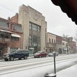
Snow that coated roads in the region Wednesday morning was changing to rain, a National Weather Service meteorologist said.
Nearly all locations in southwestern Pennsylvania will change to rain by noon as warm air moves in, meteorologist David Shallenberger said. The high temperature will be rising into the mid-40s.
The weather service updated its winter weather advisory around 11 a.m., removing Allegheny, Washington and Green counties and most of Westmoreland and Fayette counties except for the eastern ridges.
We've updated the advisory to remove the lowland counties from Allegheny Co, south. Freezing rain has developed and lowland counties still in the advisory from I-80 and south will see this continue threat through 1pm. Accumulation is still possible north of I-80 and the ridges. pic.twitter.com/dr7EzdPznO
— NWS Pittsburgh (@NWSPittsburgh) January 25, 2023
Snow was late arriving in the morning because a dry layer of air hung around the surface longer than expected Shallenberger said.
“It just turned out to be a shorter duration of heavy snow,” he said.
Numerous webcams are starting to show a reduction in visibility as snow finally begins to reach the surface across the area. To see other webcams go to: https://t.co/FVrKrw0zT8 pic.twitter.com/hTQVpLufeY
— NWS Pittsburgh (@NWSPittsburgh) January 25, 2023
As of about 9:30 a.m., the weather service had measured 1.1 inches of snow at its Moon offices. Snowfall measurements around the area ranged from 1 to 2 inches, Shallenberger said.
Despite the snow’s late arrival, it was making for tricky travel in many locations.
In Westmoreland County, Route 356 from Route 56 to the Freeport Bridge was closed shortly after 9 a.m. because of multiple vehicles being “hung up,” according to Westmoreland County 911. The road was reopened shortly after 10 a.m. once it was treated with salt.
PennDOT reduced speed limits on sections of interstates 79 and 80 to 45 mph and restricted commercial vehicles to the right lanes only because of the weather.
On I-79, the restrictions applied between Exit 76 to U.S. 19 North-Cranberry and Exit 116B I-80 West-Sharon northbound and between Exit 1116B and Exit 78 U.S. 19-Pa. 228 and Exit 77 Turnpike southbound.
On I-80, they applied to Exit 19B I-79 North-Erie and Exit 123 U.S. Pa. 970 North-Shawville east and westbound.
Shortly before 11:30 a.m., PennDOT announced that speed limit and right-lane-only commercial vehicle restrictions on I-376 in Beaver County and interstates 79 and 376 and Route 422 in Lawrence County had been lifted.
Information on restrictions is communicated on message boards, the 511PA traveler information website, and smartphone apps.
PennDOT issued an alert shortly after 11 a.m. that northbound Interstate 79 was closed between the Portersville and New Castle/Butler exits because of a jackknifed tractor trailer. The highway was not expected to reopen until 1 p.m.
Rain is forecast for the rest of the day into this evening, with snow showers after midnight as a cold front moves through and winds shift to the northwest.
Only light snow, a tenth to half an inch, is expected Thursday morning. Areas north of Pittsburgh and in the mountains could see 1 to 2 inches.
While the weather pattern is active, Shallenberger said there is no huge storm in the waiting.
Deer duo Wednesday morning in Leechburg ❄️❄️❄️@VNDNews @TribLIVE pic.twitter.com/mx6tloay5e
— Joyce Hanz (@hanz_joyce) January 25, 2023