https://triblive.com/local/regional/national-weather-service-dangerous-snow-squall-moving-through-western-pa/
‘Dangerous’ snow squall leaves behind slick roads, minor crashes in Southwestern Pa.

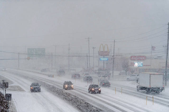
A squall that blanketed Southwestern Pennsylvania on Wednesday afternoon — leaving roads slick and myriad minor car crashes and disabled vehicles in its wake — was akin to a summer thunderstorm, just one full of snow instead of rain, said meteorologist Matthew Kramer of the National Weather Service.
“You can think about it as kind of a hybrid between a lake-effect snow band and a thunderstorm,” said Kramer, science and operations officer at the NWS office in Moon Township. “It’s the equivalent of a miniature thunderstorm squall line.”
The squall, which covered an area roughly from Steubenville, Ohio, to Johnstown, Cambria County, plowed through the region heading southeast about 35 mph, NWS officials said.
It was characterized by heavy, blowing snow which led to white-out conditions and difficult driving in some areas. Many areas received 1 to 1.5 inches of snow, with 1.3 inches recorded at the official NWS station at Pittsburgh International Airport.
Traffic heading in and out of Greensburg on Route 66 and North Main Street on Wednesday was clogged with motorists unable to navigate the snowy roads. At least two school districts in the region reported minor bus crashes related to the weather.
Squalls like Wednesday’s are driven by cold air moving over Lake Erie, Kramer said.
“That’s where the moisture comes from,” he said. “And the cold front helps develop that moist air into the squalls you see. So you get this quick-moving squall with lots of snow and low visibility. And then as quickly as those summer thunderstorms move out, this does the same.”
An NWS warning was in effect until 3:15 p.m. for southern Allegheny and northern Fayette along with Washington and Westmoreland counties.
The snow had come and gone by about 3:45 p.m. Wednesday, but cold weather will remain for at least the next few days.
The NWS forecasts frigid temperatures Wednesday night, dipping below 20 degrees and down to 14 by Thursday morning. Wind chill temperatures during Thursday’s morning commute are expected to be 4 degrees. The high Thursday is expected to reach 27 degrees.
“It will be pretty cold Thursday, but then we’re looking for it to warm up considerably by late into the weekend,” Kramer said.
The NWS has early forecasts of highs in the 50s during the early part of next week, and Kramer said temperatures may not get down to freezing on Christmas Day.
“That’s seven days out, though, so I wouldn’t give it a whole lot of credence just yet,” he said.
Copyright ©2026— Trib Total Media, LLC (TribLIVE.com)