


Some areas reported more than 2 inches of rain Saturday as thunderstorms drenched the Pittsburgh region, according to the National Weather Service.
Flash flooding and golf ball-size hail were reported, meteorologist Myranda Fullerton said.
“We saw anywhere from three-quarters of an inch total upwards of over 2 inches in some areas where stronger thunderstorms developed,” Fullerton said. “We issued quite a few severe thunderstorm warnings.”
The National Weather Service issued a tornado warning that included the panhandle of West Virginia and portions of Washington County.
Fullerton on Sunday morning said the weather service is trying to determine whether a tornado occurred. A survey will likely be done using photos emailed to the NWS by people on the scene.
“We warn off of radar signatures, and then we try to get reports from spotters in the area to help confirm that,” Fullerton said.
Roadway and basement flooding were reported in municipalities across Allegheny County.
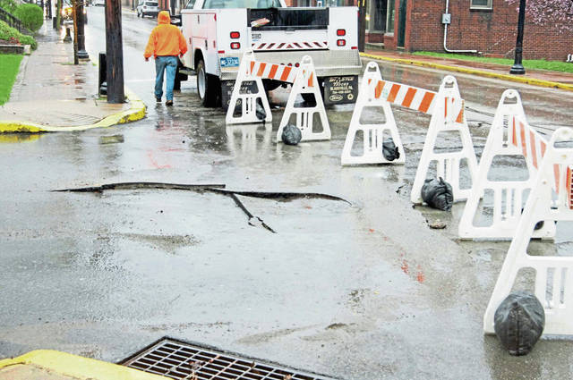
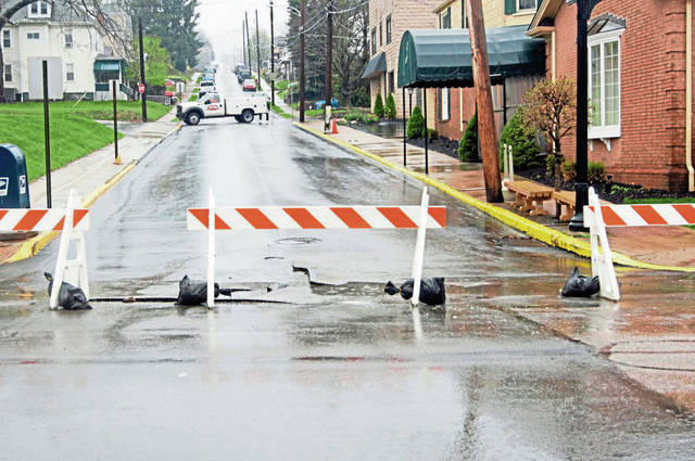
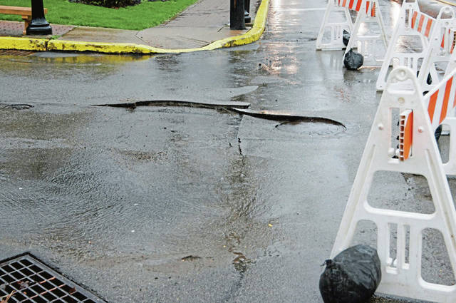
In Springdale, heavy rains caused the pavement to buckle Saturday evening at the intersection of James and Pittsburgh streets.
Springdale police said James Street was closed from Pittsburgh Street to Walnut Street.
In Franklin Park, the 1500 block of Ingomar Heights Road was subsiding because of flooding, according to a tweet from Allegheny County.
Franklin Park - 1500 Ingomar Heights Rd - roadway subsiding due to flooding
— Allegheny County (@Allegheny_Co) March 28, 2020
Allegheny County: municipalities throughout county reporting basements flooding; water coming into homes
— Allegheny County (@Allegheny_Co) March 28, 2020
Marshall: 1300 block Royal Oak Drive - roadway, yards flooding
— Allegheny County (@Allegheny_Co) March 28, 2020
Mt. Lebanon: Cedar Blvd at Greenhurst Drive - roadway flooded
— Allegheny County (@Allegheny_Co) March 28, 2020
People tweeted pictures of large chunks of hail that reportedly fell in Bethel Park, Cecil-Bishop and Canonsburg during the storms.
@NWSPittsburgh Bethel Park hail pic.twitter.com/saeBbrLfsT
— Todd Hendry (@THendry35) March 28, 2020
@NWSPittsburgh Hail reported in Bishop, Cecil Township, Washington County at 4:22 PM. pic.twitter.com/83sEWgIOfY
— DJ Johnson (@SCChargerFC) March 28, 2020
@NWSPittsburgh Hail in Canonsburg, PA (Network Dr.) pic.twitter.com/KdMOQUZgW7
— Steve Jackman (@CTownPride) March 28, 2020
More storms rolled through the region Sunday with expectations of strong winds, hail and possibly an isolated tornado, Fullerton said.
“We are under a slight risk for severe weather today,” Fullerton said Sunday morning. “We have a cold front that’s approaching, and we’re expecting additional thunderstorm development ahead of the front basically now midday through late afternoon.”
A flood advisory for the Ohio River in the city of Pittsburgh will remain in effect until 2 p.m. Tuesday. A wind advisory was in effect until 9 p.m. Sunday.
A wind advisory is in effect until 9 PM tonight. Expect a sustained wind of 15-20 mph, or higher, with occasional gusts up to 55 mph. In fact, the Pittsburgh International Airport recorded a 51 mph gust just moments ago. Wow! Secure your garbage cans and any other loose items. ? pic.twitter.com/oG3jDRpJIU
— NWS Pittsburgh (@NWSPittsburgh) March 29, 2020
Monday and Tuesday are expected to be dry with highs in the 50s. There is a chance of showers Tuesday night.