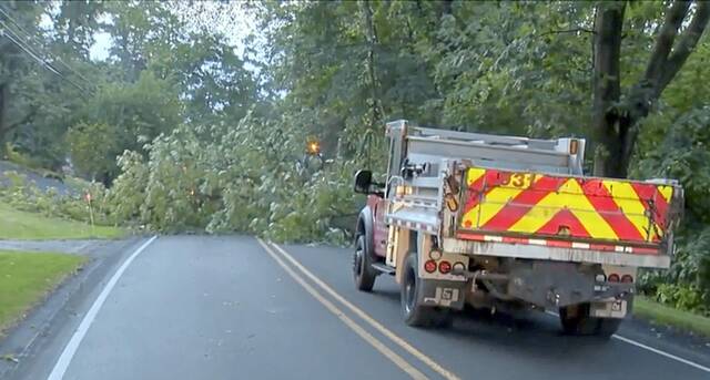
Severe thunderstorms and damaging winds moved through Western Pennsylvania late Thursday, leaving thousands in the region without power.
As of 11:30 a.m., just under 2,000 customers remained without electricity, including about 1,600 West Penn Power customers.
While the number of outages has dropped as the day wears on, the bulk of the outages continue to be in Westmoreland County, with nearly 850 customers still out.
Allegheny County suffered mostly from flash floods caused by the storm, particularly in the Mon Valley and along the Route 51 corridor, said Lee Hendrix, meteorologist at the Pittsburgh’s office of the National Weather Service.
Rainfall totals ranged from about three-quarters of an inch in Carnegie to 1.78 inches in Glenshaw, said Hendrix.
He said the rain fell quickly in less than 45 minutes and with some parts of Allegheny County prone to flooding, flash floods are produced with relative ease.
Hendrix said topography and urban density of parts of the Mon Valley and the city make the area prone to floods.
Related
• Salem barn destroyed by fire following lightning strikeWhitehall, West Mifflin, Pleasant Hills and the area near the Duquesne-McKeesport Bridge all saw flash flooding around 11 p.m. Thursday. There also was a report of a vehicle stuck in flood water on Idlewood Road in the East Carnegie neighborhood of Pittsburgh, he said.
According to the police scanner, there was some flooding on Allegheny River Boulevard by the Lock & Dam restaurant in Pittsburgh.
“If you get that amount of rain in 45 minutes, that will do it,” Hendrix said. “In that heavily urbanized area, the streams are very congested.”
Hendrix said Allegheny County mostly avoided damage from severe winds, but that parts of Butler and Mercer counties were hit hard.
David Shallenberger, NWS’s lead meteorologist, agreed that the Pittsburgh region and parts south were spared the brunt of the evening’s storms.
“It does seem that the greatest winds were up in the northern counties along (Interstate) 80 and then it kind of trailed off a little bit as the line sags south,” he said. “We knew (the storm system) would weaken as it came south. It just ended up being a little bit slower, so there’s a little bit more flooding than what we anticipated.
“It all goes back to how that line of storms moved. The strongest winds were to the north which is where the enhanced risk originated from. So there was really nothing too out of hand other than what we anticipated.”
As for Friday’s forecast, the NWS said to expect a mix of sun and clouds, with seasonably cool temperatures. The forecast shows that an isolated shower is possible in the northern and eastern regions of Pittsburgh. However, most of the day will be dry.
Expect a mix of sun and clouds today along with seasonably cool temperature. An isolated shower can't be ruled out for locations north and east of Pittsburgh, but it will overall be dry.
— NWS Pittsburgh (@NWSPittsburgh) July 21, 2023
That dry weather has a high probability of continuing through the rest of the weekend. pic.twitter.com/YApCqy2dQb
The NWS said the dry weather has a high probability of carrying through the weekend.
Staff writer Ryan Deto contributed to this report.