


A group of surveyors from Pennsylvania and Maryland starting this year plan to create a new record of what might be America’s most famous border: the Mason-Dixon Line.
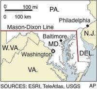
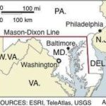
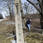
Members of both states’ surveyor societies will help survey the 196-mile border stretching from Delaware to the southeastern tip of Fayette County, where Pennsylvania, Maryland and West Virginia meet, said Richard A. Ortt Jr., director of the Maryland Department of Geological Survey, which is overseeing the project.
“It’s more of a reconnaissance survey,” Ortt said, noting it won’t lead to any changes to the border between the states. Work is scheduled to start this month and be completed by August 2021.
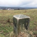
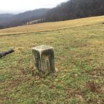
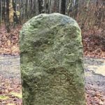
Surveyors will make a new record of the stone markers that Charles Mason and Jeremiah Dixon laid in the late 1760s along the border of the two British colonies to settle a decades-long dispute.
Mason and Dixon were commissioned to survey a border line between the colonies that ran along the 39th northern parallel, 43 minutes, which is roughly 47 miles north of 39th parallel. They laid stone markers at one-mile and five-mile intervals “to make sure people weren’t moving the (border) line,” Ortt said.
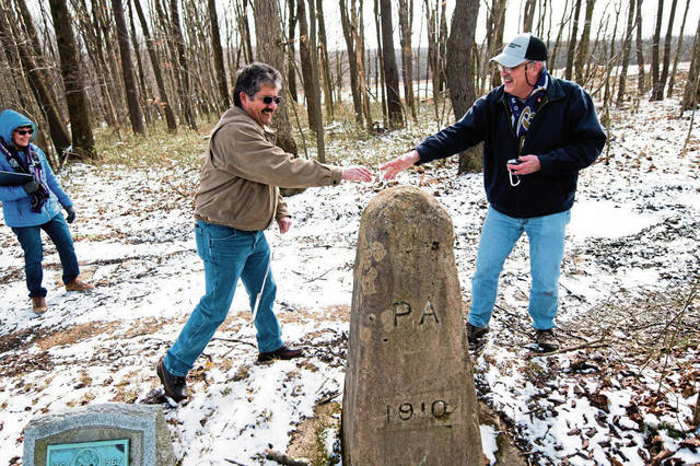
Over the centuries, however, markers have been moved and some were replaced by replicas, said Eric Gladhill, a Gettysburg surveyor and the Pennsylvania director of the volunteer project. Some markers were moved in the early 1900s and set in new concrete — but not always exactly along the border, Gladhill said.
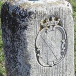
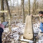
Ortt is not certain how many originals remain, either the mile markers or the five-mile crowning stones, which weigh some 600 pounds. The crowning stones had the crest of William Penn’s family with a “P” on the Pennsylvania side and Maryland’s Lord Calvert’s coat of arms with a “M” on the other side, Ortt said.
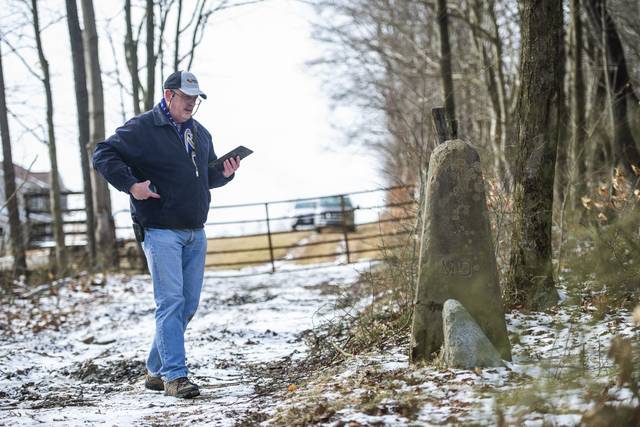
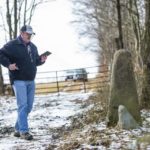
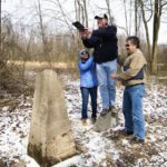
Rather than lugging transits up and down the hills and through the woods in search of the monuments, surveyors will use a smartphone app to record data about marker locations and take photos, Ortt said. They do not intend to dig up property in an effort to find any buried stones.
Maryland’s geological survey department, which is required by state code to conduct the survey every 10 years, will process the photos and data. This will be the first complete survey in 40 years, according to the Maryland Department of Natural Resources.
The idea of doing another survey was “percolating for about two years,” Gladhill said.
“There’s always been a lot of interest in the Mason-Dixon Line,” said Gladhill, who lives near the Maryland border.
Ortt said a few surveyors have signed up to participate. A big push for the surveyors to walk the border through farmlands and woods will be the third week of March, which is National Surveyors Week.
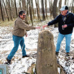
Patrick Simon, chief of surveys for Baltimore County, Md., on Saturday started surveying the Mason-Dixon line along the border where Maryland, Pennsylvania and West Virginia meet.
“The end goal is to get the stones placed on the National Register of Historic Places,” Gladhill said.
Getting historic status would allow interested organizations to get grants to maintain and preserve the stone markers, he said. The deadline was set for August 2021 because the National Register will not consider data more than two years old for a historic designation.
Border battles
The battle between Pennsylvania and Maryland over the location of the border was rooted in the charters each received in the 1600s.
King Charles I in 1632 granted Cecil Calvert land with a northern border of 40 degrees north latitude, which would have placed Philadelphia within Maryland’s colonial borders. The charter William Penn received in 1681 put the southern border of his land at the 40th latitude, but the Penn family was not interested in relinquishing Philadelphia to the Calverts, according to the Pennsylvania Historical and Museum Commission. Penn’s colony drew its southern border just north of Havre de Grace, where the Susquehanna River empties into the Chesapeake Bay.
With tax money at stake, the border battle turned violent in the 1730s with Cresap’s War. Soon, militia from both colonies entered the fray. King George II was forced to negotiate a truce between the squabbling colonies.
Mason, an astronomer, and Dixon, a respected surveyor, started in 1765 at a point 15 miles south of Philadelphia. Moving westward toward the Susquehanna River, they used Native American guides to keep them safe. In southern Greene County, near Dunkard Creek, they were warned not to go further because of hostile Indians.
The Mason-Dixon Line became famous as the dividing line between the Northern and Southern states during the Civil War.
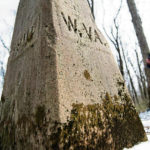
The line divides Ernest Umbel’s 200-acre farm just south of Markleysburg, neatly dividing the farm into 100-acre parcels — half in Garret County, Md., and half in Henry Clay Township, Fayette County. The farm is about three miles east of the tri-state border of Pennsylvania, Maryland and West Virginia.
No welcome signs notify drivers on Friendsville Road that they are entering or leaving either state, though a marker does tell them they are in Henry Clay Township, Fayette County. That sign is close to but not really at the border, said Umbel, a retired Garrett County industrial arts teacher.
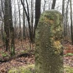
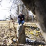
A marker for the Mason-Dixon line can be found on the Umbel property his grandfather acquired at least a century ago. Protruding from the ground about 2.5 feet, one side is marked “P” and the other “M”. It is marked with the number 367 and dated 1902.
Growing up, the 67-year-old Umbel said he lived in a farmhouse built on the Pennsylvania side of the border, so he traveled some 21 miles along Route 40 and down Laurel Summit into Uniontown to go to high school. Now, he lives in a house across the two-lane highway and about 20 yards to the south — in Maryland.
“I get to pay (property) taxes in two states,” Umbel joked, noting that taxes in Garrett County are a little cheaper than those in Fayette.