Western Pennsylvania is gearing up for a snowy weekend.
Shannon Hefferan, a meteorologist with the National Weather Service in Moon, said 3 to 6 inches could start falling around 3 p.m. Saturday.
Depending on geographical location, though, some areas will see more snow than others, she said.
In the Pittsburgh region, 4 to 5 inches of snow will fall. Closer to the ridges of the Appalachian Mountains, there could be 8 to 10 inches, according to Hefferan.
“It’ll be that fluffy kind of powdery snow,” she said. “If you’re expecting it to melt, it won’t.”
Hefferan said the heaviest snowfall is expected from Saturday night into early Sunday. Wind chills will dip to around zero on Sunday and remain that low through Monday morning.
????????EXTREME COLD: Arctic air moves south Fri-Sun, bringing life-threatening wind chills (below -30°F in some areas) and temps 20-30°F below normal from the Plains to the Mid-South. Prepare now to protect people, pets, and pipes. pic.twitter.com/JGWWKwTLXM
— NWS Weather Prediction Center (@NWSWPC) December 11, 2025
There is a winter storm watch from 2 p.m. Saturday until 2 p.m. Sunday, according to the National Weather Service.
Hefferan said light snow is expected between 3 and 6 p.m. Saturday, with snowfall rates picking up between 7 and 11 p.m. across Western Pennsylvania.
“Travel will be very bad during the overnight … with the snow amounts,” Hefferan said. “If you can avoid traveling, I would just definitely try to do that.”
By Monday, the snowstorm will exit. Temperatures will remain cold.
“It will be very uncomfortable to shovel, so you want layers,” Hefferan said. “When you do shovel the next day, bundle up.”
But that doesn’t mean the snow that’s accumulated is going away.
Hefferan predicted most of the snow likely will melt midweek, as temperatures are expected to reach the low 40s.
Before that, Western Pennsylvania will be stuck below freezing, she said.
The temperature forecast is as follows:
- Saturday highs around 34 or 35 degrees, overnight lows in the low teens
- Sunday highs in the low 20s and the high teens, overnight lows dipping to around 10 to 12 degrees
- Monday and Tuesday will be slightly warmer with temperatures in the low 20s
“The best rebound to get above freezing is Wednesday,” Hefferan said. “The cold will kind of last through Wednesday at least below freezing.”
Preparation in Allegheny County
Allegheny County Department of Public Works Director Stephen Shanley said Friday the department is prepared.
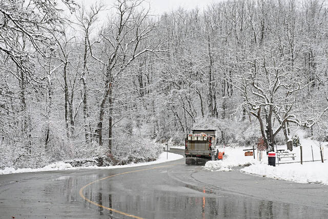
When snow begins to fall Saturday, the department will deploy 24 salt trucks installed with plows, he said. They will continually plow and salt county-maintained roads until the snow stops falling and all roads are clear.
The department is responsible for clearing 357 miles of roadway.
“We likely will add more trucks when the snowfall is expected to be heaviest Saturday afternoon through early Sunday morning,” Shanley said.
The trucks will use the department’s 9,387 tons of salt and 2,615 gallons of liquid calcium chloride it has in stock, which “is more than enough to handle the forecasted snowfall,” according to Shanley.
“It typically takes our drivers about one to two hours to complete their routes and then about an hour to return to the nearest maintenance garage, reload with salt and restart their routes,” he said. “So, when the snowfall is heaviest (Saturday), there will be accumulation and slick spots on our roadways.”
The department is asking Allegheny County residents to stay off the roads, if possible, when snowfall is the heaviest so everyone will stay safe and salt truck drivers can clear the snow faster, Shanley said.
“If residents have to venture out, we encourage them to ensure that their tires are in good condition, slow down, avoid making any sudden turns or stops, leave extra space between their vehicle and the one in front of them and stay six car lengths behind our salt trucks,” he said.
If a resident needs to report a snow or ice issue on a county-maintained road this weekend, they should call 911, Shanley said. Residents can see who is responsible for removing snow from any road within the county by visiting the Who Plows My Road website.
Pittsburgh’s Department of Public Works also said it is preparing for this weekend’s winter weather.
There is planned 24-hour coverage of streets beginning at 10 a.m. Saturday until 6 a.m. Monday.
Streets providing access to hospitals, emergency routes and public safety facilities will be given priority, the department said.
It takes up to 24 hours after the snow stops for all city streets to be treated, according to the department. If a street hasn’t been cleared within that period, residents can contact 311 for assistance.