

Longtime residents of Bethel Park are well aware of, or even may remember, a time when King Coal ruled local industry.
At various points in the 20th century, seven different mining operations worked to extract combustible carbon from far below what used to be Bethel Township, leaving only a small portion of the municipality apparently untouched.
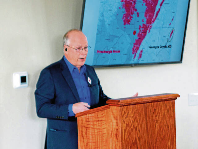
For the inaugural event in a planned Bethel Park Historical Society lecture series, retired mining professional Warren Merritt took a deep dive, if you will, into the portals and tipples of yesteryear.
“The first coal mined in Bethel Park was at the bottom of the shaft at Mollenauer in 1901,” he told a packed audience on March 11 at the Schoolhouse Arts and History Center, referring to the operation based in and around at today’s intersection of Milford Road and Route 88.
As for the final extractions, they took place in 1960, the same year Bethel Township became Bethel Park, near the southwestern corner of the municipality.
Merritt calculated that in between, mining companies removed almost 47 million tons of coal. The only area in Bethel Park for which he could find no record of extraction is about 84 acres extending from the southern portion of the South Park Township line.
Of course, much of Western Pennsylvania endured similarly heavy concentrations of underground mining, with good reason.
“The primary seam under Bethel Park and this whole area, and probably the most prolific and the most economically important seam in the United States, was the Pittsburgh seam,” Merritt said.
Despite substantial mining since the 19th century, 16 billion of the original 34 billion tons of coal remain in the seam, according to digital resource modeling by the U.S. Department of the Interior.
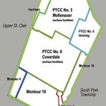
At any rate, two entities led the way during Bethel’s six-decade run on withdrawing subsurface carbon: Pittsburgh Terminal Railroad & Coal Co. and the similarly, thus confusingly, named Pittsburgh Coal Co., which in 1945 merged with what now is Consol Energy Inc.
Only two mines, both owned by the former, ran their above-ground operations locally, Mollenauer (PTTC Mine No. 3) and Coverdale (No. 8).
“The other ones had outside surface facilities,” Merritt said about their locations in different municipalities. “So they came in from the outside, mined under Bethel Park and then went away.”
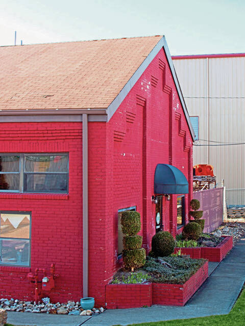
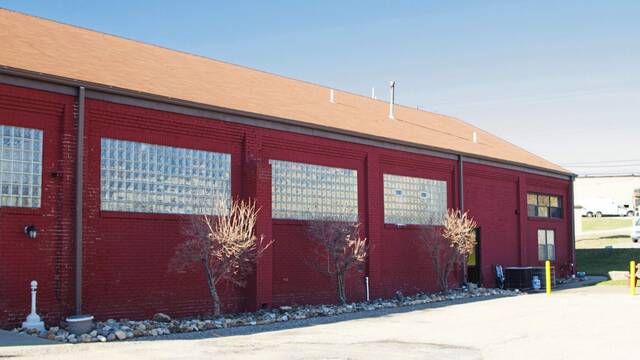
When it opened in 1920, Coverdale featured both state-of-the-art equipment and housing for employees and their families. The resulting neighborhood continues to thrive today, with many residents taking pride in its distinctive history.
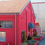
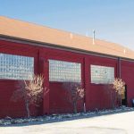
By contrast, only two buildings from the mining operation seem to be intact, within the current site of Bethel Park Industrial Park. The hoist house once containing machinery for lowering and raising, and the bathhouse provided a place for employees to wash up a bit before walking home.
Not much remains, either, of the Mollenauer operation, although one of its least-appealing features now has a productive purpose. In 2020, the Allegheny Land Trust purchased property containing the overgrown top of a massive mine refuse dump, and the tract now serves as the Bethel Green Conservation Area.
Since Merritt’s retirement after 45 years in the mining business, he has consulted for companies about potential hazards associated with his industry on proposed commercial, residential and natural gas land development.
“When it was for sale,” he said about the future Bethel Green acreage, “a client had me do an investigation to see what was going on there. And the results of my investigation, they backed out of that deal so quick it was unbelievable.”
By his estimate, between 300,000 to 400,000 cubic yards’ worth of material was discarded.
“If you had to pay $20 a yard to get that out of there,” he said, “you couldn’t afford to build houses.”
The site happens to overlook St. John the Baptist Byzantine Catholic Cemetery, where Andy Warhol is buried. So Merritt, according to what he told his audience, suggested that his clients build townhouses resembling tomato soup cans in honor of the artist’s most recognized work.
“They didn’t have a sense of humor,” Merritt reported, displaying his.
Whatever the case, the conservation area now offers a place that can withstand development in perpetuity.
“It really doesn’t impact the local environment,” Merritt said. “But it does make a nice park.”