Do treasure chests full of gold and jewels rest beneath the Pennsylvania waters of Lake Erie off eastern Erie County?
Probably not.
But scientists, who are using an uncrewed surface vehicle to explore and map nearly 100 square miles of lakebed along the Pennsylvania, New York and Canadian borders, are still likely to find treasure, said Jim Hall, site administrator for the Erie Maritime Museum.
“Any underwater cultural resource you find out there is treasure,” Hall said. “It doesn’t have to be gold doubloons.”
The museum is hosting the scientists and other professionals from the Ocean Exploration Cooperative Institute funded by NOAA, the Center for Coastal and Ocean Mapping at the University of New Hampshire, Chance Maritime Technologies and R2Sonic. They have been working since Sept. 29 and will continue through Oct. 18. The public should be able to learn more about the project at an open house this month.
Val Schmidt, a research project engineering manager who is from the University of New Hampshire, said that understanding the shipwrecks and other archaeological sites under Lake Erie is helpful to understanding the past.
What is the team doing?
The northeast corner of Pennsylvania’s portion of Lake Erie is among the least surveyed, according to information from Hall.
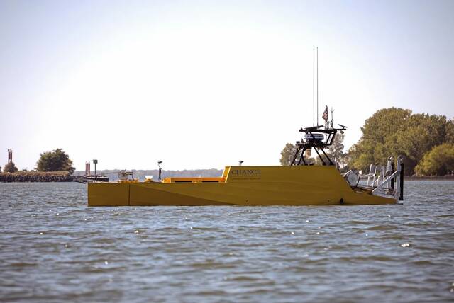
This public-private partnership will bring advanced technology to identify with greater nuance the unique features on the lakebed that might have been missed during prior surveys. The survey area is among the deepest areas of the eastern basin of Lake Erie, with depths ranging from 114 to 180 feet. The project will map about 98 square miles of lakebed using the LR30 UV, an uncrewed surface vehicle, and the Voxometer, a state-of-the-art sonar survey system.
Hall said the team works from a command center trailer on the museum grounds to send an unmanned 30-foot-long yellow USV onto Lake Erie. The USV operates similarly to how a Roomba robotic vacuum would on land, he said, and obtains a “photographic lay of the land underneath the water.”
Schmidt said boaters might catch sight of the USV on the lake and asked them to keep their distance from it.
What might they find?
Shipwrecks are likely to be discovered, Hall said, but he doesn’t expect them to yield precious metals or stones.
“I think there’s a lot of coal out there,” he said, adding that lumber, limestone and pig iron were also carried by ships on Lake Erie.
He said the survey could also reveal cultural history, such as what the land looked like before it was under water and when it was occupied by the Seneca people.
Schmidt said Oct. 8 that he couldn’t yet reveal what the team has come across.
What will happen with the results?
Hall said information discovered by the team will be shared with the museum.
“Anybody using our resources, we want the public to benefit from it,” he said.
Schmidt said the data also would be released eventually by the National Oceanic and Atmospheric Administration.
A screen is located in the museum showing a live feed of the work and will remain there during the project for people to learn about it even if they miss the open house, Hall said.