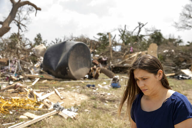
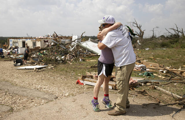
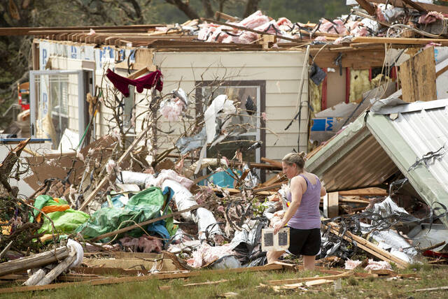


SALADO, Texas — Nearly two dozen people were injured when tornadoes swept through central Texas as part of a storm system that was expected to spawn more twisters and damaging wind Wednesday.
The storms caused widespread damage Tuesday in Salado, about 50 miles north of Austin. Bell County Judge David Blackburn said 23 people were injured, one of them critically. Twelve of the injured were taken to hospitals, Blackburn said.
“There’s not much left,” said Blackburn, the county’s top elected official. “Large trees are uprooted and overturned and stripped. Buildings really reduced to rubble. … Power lines, power poles, are scattered all over the place. It’s pretty devastating.”
NEW VIDEO: Take a look at the damage in Salado, Texas from storms on Tuesday night. #TXwx pic.twitter.com/HKW6Xrg4x9
— FOX Weather (@foxweather) April 13, 2022
Photos on social media showed grapefruit-size hail associated with that storm.
Tornadoes were also spotted Tuesday in Iowa, but there were no reports of serious injuries. In Lincoln, Neb., powerful wind gusts knocked down tree limbs and caused some roof damage. A possible tornado also caused damage in the small southern Minnesota town of Taopi near the state’s border with Iowa.
CRAZY! Check out this picture of hail in Bell County, Texas. Severe storms injured over 20 and sent a dozen people to the hospital. (????: Gina Brown) pic.twitter.com/Pl58NSqYlb
— WLBT 3 On Your Side (@WLBT) April 13, 2022
Mower County Sheriff Steve Sandvik said dispatchers began getting calls from residents trapped in their damaged homes not long after a tornado warning siren sounded at 10:30 p.m. Tuesday. There were no reports of serious injuries. Weather service crews were assessing damage in the area Wednesday.
More tornadoes were in the forecast Wednesday for parts of the mid-South and in the Mississippi River Valley, the Storm Prediction Center said.
Get the latest on tonight's severe weather threat on The Weather Channel. @JenCarfagno and @JMichaelsNews give updates from Memphis, Tennessee and Paducah, Kentucky: pic.twitter.com/heFbWt9ZFY
— The Weather Channel (@weatherchannel) April 14, 2022
Hurricane-force wind, intense tornadoes and large hail were possible in Arkansas, Illinois, Tennessee, Missouri, Kentucky, Mississippi, Indiana, Louisiana and Alabama, forecasters said. Little Rock, Ark., and Memphis, Tenn., were among the cities that could see the worst weather Wednesday, the Storm Prediction Center said.
Elsewhere, the North Dakota capital, schools, government offices and interstates remained closed Wednesday as a blizzard continued to bear down on the state.
RealFeel temperatures are projected to dip below zero over hundreds of thousands of square miles in the north-central region by Thursday. https://t.co/rHbZOgUY3q pic.twitter.com/NOxzNCsnJp
— AccuWeather (@accuweather) April 13, 2022
A blizzard warning issued by the National Weather Service remained in effect through Thursday for most of western and central North Dakota where up to 2 feet of snow was expected.