https://triblive.com/news/world/chantal-now-a-tropical-depression-raises-concerns-of-flash-flooding-in-north-carolina-and-virginia/
Chantal, now a tropical depression, raises concerns of flash flooding in North Carolina and Virginia

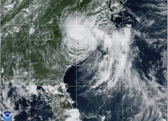
MIAMI — Tropical Storm Chantal was downgraded to a depression Sunday but raised concerns of possible flash flooding as it makes its way through central North Carolina toward south-central Virginia.
Chantal made landfall near Litchfield Beach, South Carolina, at about 4 a.m. EDT Sunday, the National Hurricane Center in Miami said. At 5 p.m., it was located about 65 miles south-southwest of Raleigh, North Carolina, and was moving north-northeast at 10 mph with maximum sustained wind of 30 mph.
7:45pm EDT 7/6 Flash Flood Warnings are ongoing across portions of North Carolina due to heavy rain from Tropical Depression #Chantal. Remember, turn around, don't drown, if you encounter water of unknown depth on the roadway. Flooding is especially dangerous at night. Monitor… pic.twitter.com/hFN3qTLYlP— National Hurricane Center (@NHC_Atlantic) July 6, 2025
The system was expected to turn more to the northeast late Sunday as it weakens over North Carolina but may strengthen slightly as it approaches the Virginia Capes on Monday. Flood watches were issued for central North Carolina and south-central Virginia through Monday, with total rainfall of 2 to 4 inches and local amounts up to 6 inches that could lead to flash flooding, the hurricane center said.
Sand and wind blasted North Myrtle Beach as Tropical Storm Chantal rolled in late Saturday.The storm made landfall in eastern South Carolina, bringing flash flooding as heavy rainbands moved inland.#scwx pic.twitter.com/MbcZXG15aH
— WeatherNation (@WeatherNation) July 7, 2025
Forecasters said dangerous surf and rip currents at beaches from northeastern Florida to the mid-Atlantic states are expected to last for the next couple of days.
Copyright ©2026— Trib Total Media, LLC (TribLIVE.com)