


HONOLULU — President Joe Biden approved an emergency declaration as an intensifying Super Typhoon Mawar approached Guam, where anyone not living in a concrete house was urged to seek safety elsewhere and emergency shelters began to fill ahead of what could be the most powerful storm to hit the U.S. Pacific territory in decades.
Gov. Lou Leon Guerrero said on social media that the declaration will support the mobilization of resources into Guam, which is “especially crucial given our distance from the continental U.S.” Guerrero ordered residents of coastal, low-lying and flood-prone areas of the territory of over 150,000 people to evacuate to higher elevations.
Federal assistance will be needed to save lives and property and “mitigate the effects of this imminent catastrophe,” Guerrero said in a letter to the president requesting a “pre-landfall emergency” for Guam. Officials warned residents who aren’t in fully concrete structures — some homes on the far-flung island are made of wood and tin — to consider relocating.
For #TimelapseTuesday we're featuring 4-day infrared imagery via Japan's #Himawari9 satellite of #SuperTyphoon Mawar's path in the Pacific towards Guam.
— NOAA Satellites (@NOAASatellites) May 23, 2023
At the last report, #Mawar had sustained winds of 155 mph.
Updates: https://t.co/G0fr1m7VKP pic.twitter.com/fP8hce7n0y
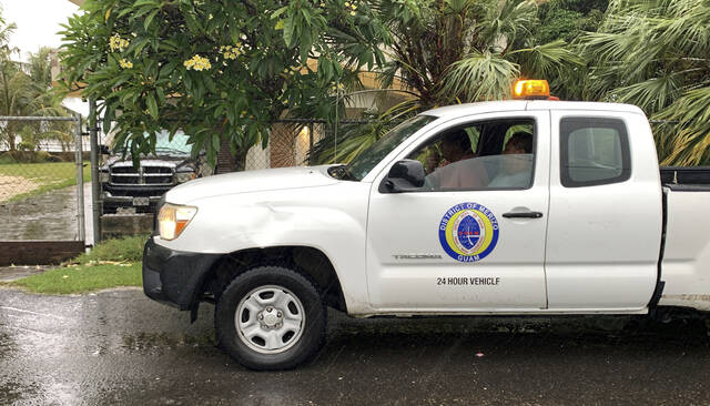
Guam is a crucial hub for U.S. forces in the Pacific, and the Department of Defense controls about a third of the island. Naval Base Guam has been tracking the storm since last week and preparing for it, including sending ships away from the island, a standard precaution, base spokesperson Valerie Maigue told the military newspaper Stars and Stripes by phone Tuesday.
Rear Adm. Benjamin Nicholson, Joint Region Marianas commander, authorized the evacuation of defense personnel, dependents and employees in areas expected to be affected by the storm.
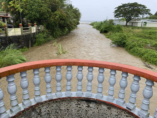
With rain from the storm’s outer bands already falling on the territory, the National Weather Service said the storm had been upgraded to a Category 4 “super typhoon,” meaning maximum sustained winds of 150 mph or greater. Its center was about 90 miles southeast of Guam early Wednesday local time and was moving to the north-northwest, according to the weather service.
The seas are angry in Guam where Super Typhoon #Mawar is closing in on the island. The National Weather Service said "Large ships should be secured as they will be torn
— WeatherNation (@WeatherNation) May 23, 2023
from moorings" pic.twitter.com/gtOYOAE615
The weather service said the storm was intensifying and warned of a “triple threat” of wind, torrential rains and life-threatening storm surge on Guam. The weather service said the storm could hit southern Guam around midday Wednesday, which is Tuesday evening in the continental United States. Guam lies west of the International Date Line and is a day ahead of the U.S. mainland and Hawaii, which is 3,800 miles to the east. Manila, the Philippine capital, is 1,600 miles to the west.
If Guam doesn’t take a direct hit, it will be very close, said Patrick Doll, the lead weather service meteorologist in Tiyan, Guam. Mawar is a Malaysian word that means “rose,” he noted.
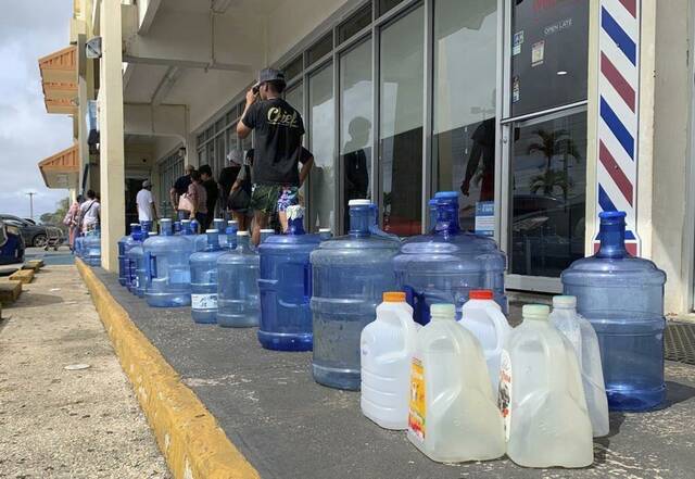
Guerrero urged residents in a YouTube message to remain calm and ordered the National Guard to help those in low-lying areas evacuate as people stocked up on water and generators.
“We are at the crosshairs of Typhoon Mawar,” she said. “Take action now, stay calm, stay informed and stay safe.”
First light, 997mb dropping here we go. #Guam #Mawar pic.twitter.com/XCAPrFqToQ
— Jim Edds (@ExtremeStorms) May 23, 2023
A storm surge of 6 to 10 feet above the normal high tide was expected and could reach as high as 15 feet. Surf was expected to build sharply in the next day or two along south- and east-facing reefs, with dangerous surf of 20 to 25 feet into Wednesday, the weather service said.
The storm was moving at only 3 mph but had an eye 17 miles wide, meaning people at the typhoon’s center could see calm conditions for over three hours and conclude, far too soon, that the worst is over, Doll said. As the eye leaves, the winds could rise to 150 mph in minutes, so people should remain sheltered until the government gives the all-clear, he said.
“Folks may say, ‘Hey it’s over, we could go outside and start cleaning up,’” Doll said. “That is totally wrong.”
Typhoon Mawar heading for direct hit on Guam.
— AFP News Agency (@AFP) May 24, 2023
Packing potentially catastrophic winds, Mawar could cause widespread flooding and damage on the US territory in the Pacific, which is home to a crucial military outposthttps://t.co/d2gV24Ysk0 pic.twitter.com/JhAAL0cf9M
The weather service warned that “considerable” was expected, including non-reinforced concrete walls being blown down, fuel storage tanks rupturing, overturned cars and uprooted trees that could cut off residential areas for days to weeks.
Guam resident Albert Eliasson told KUAM News he was battening down and stocking up, including ensuring there was enough water to drink and flush toilets.
“Just making sure that we have things prepared, shutters on the windows that need it,” he said.
Another resident, Oshean Saralu, told KUAM he too was doing everything he could to prepare: “We usually pack everything up for most of our stuff inside our garage and just secure everything, especially the windows.”
Rota, an island in the U.S. Commonwealth of the Northern Mariana Islands, was also under a typhoon warning, Doll said. Tinian and Saipan, in the Northern Marianas, were under tropical storm warnings. Some people in those areas are still in temporary shelters or tents after Category 5 Super Typhoon Yutu in 2018, Doll noted.
While other storms have skirted Guam, the last Category 4 storm to make a direct hit was Pamela in 1976, University of Miami hurricane researcher Brian McNoldy said.
Typhoon season runs from July 1 to Dec. 15 in the western North Pacific, according to the weather service.
“Mawar isn’t terribly unusual in location, but certainly in strength,” said University of Albany atmospheric science professor Kristen Corbosiero, a tropical cyclone expert. Usually one or two storms a year come within 50 miles of the island, she said.
The western Pacific is “a notorious breeding ground for intense tropical cyclones,” said Yale Climate Connections meteorologist Jeff Masters. “They’ve got a much bigger area to romp around in and more time to intensify.”
If Mawar hits Guam as a Category 4 storm, the second highest category, it will be the ninth of that category or stronger to hit the United States or its territories since 2017, Masters said, calling it “unprecedented.”
The National Oceanic and Atmospheric Administration has warned that in a warmer world, the number of Category 4 or stronger storms will increase by 10% — and Mawar “could well be a harbinger of the type of battering that the U.S. could expect to see in a warmer climate,” Masters said.