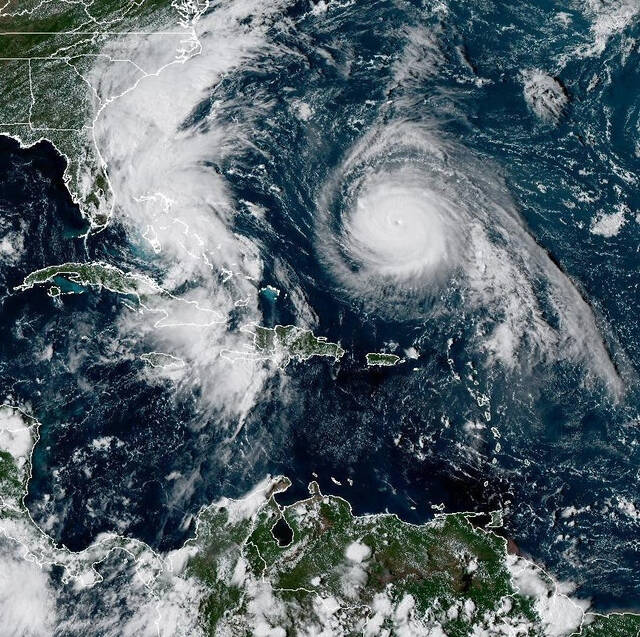
Tropical Storm Imelda has formed in the Bahamas and is forecast to bring rain, rip currents, storm surge and rough surf to much of the Southeast coast through the middle of the week of Sept. 29.
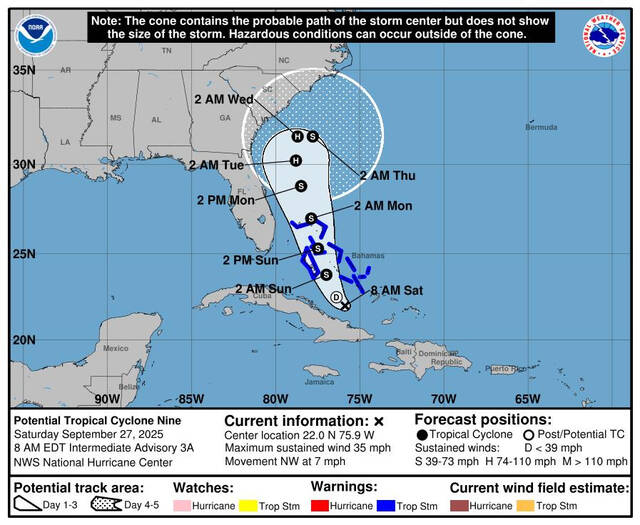
At 2 p.m. on Sept. 28, Imelda’s sustained winds had just barely reached the point — 40 mph — strong enough to be considered a tropical storm, the National Hurricane Center said. It was centered about 95 miles west-northwest of the Central Bahamas and about 370 miles southeast of Cape Canaveral, Florida, and moving north at 7 mph.
The hurricane center’s official forecast calls for Imelda to organize as it moves northward offshore parallel to the Florida coast. But by Tuesday, forecasters expect it to strengthen into a hurricane as it begins to make a right turn out into the open Atlantic away from the mainland United States.
Several days of heavy rain from future Imelda could lead to flooding in the Carolinas. Meteorologist @StephanieAbrams is in Myrtle Beach, South Carolina, with the latest on the storm’s track and timing: pic.twitter.com/T7oeQ7TqOQ
— The Weather Channel (@weatherchannel) September 28, 2025
While that improves the forecast for the United States, the island of Bermuda is now in Imelda’s crosshairs in the latest forecast track issued on Sept. 28, with a potential landfall of a Category 1 Hurricane Imelda on Thursday, according to the hurricane center forecast.
“The risk of significant wind impacts along the southeastern United States coast is decreasing,” Philippe Papin, one of the center’s hurricane specialists, wrote in an update. But for people with interests along the already battered beaches of the East Coast from previous storms this summer, it could be a very long week, based on the forecasts.
Rain chances also remain high enough that there’s a marginal to slight chance of flash flooding from just north of Miami all the way north to the Raleigh-Durham area in a wide arc through the Carolinas.
East Central Florida remains under a tropical storm watch, and the entire Southeast coast is advised to remain alert for rough conditions right at the coast and along coastal waters, with surf and seas stirred up by Imelda, but also from distant, but strong Hurricane Humberto, now a Category 4 with 150 mph winds.
A storm surge of 1 to 2 feet is forecast along the coast from Central Florida to the South Santee River in South Carolina, and minor coastal flooding could occur along the coast as a result of onshore, Papin wrote in the forecast update. Swells from Humberto and Imelda are expected to create dangerous rip currents along the east coast of Florida and the Georgia coast through Sept. 29, and could continue north through the rest of the week.
“We want to stress that this has the potential to be a longer-duration swell event for the (eastern North Carolina) coastline and for the ENC coastal waters, with peak swell and marine impacts expected Tuesday — Thursday,” said Casey Dail, a meteorologist at the National Weather Service office in Morehead City, North Carolina. But additional coastal and inland impacts could occur, based on Imelda’s ultimate forward path.
A tropical storm watch extends along the east coast from the border of Palm Beach and Martin counties north to the border between Volusia and Flagler counties, meaning tropical storm conditions are possible within 24 hours. The hurricane center shows the probability of tropical storm force winds along the coast of Florida ranging from a 9% chance in West Palm Beach on Sunday to an 11% chance in Fort Pierce and an 8% chance at the Patrick Space Force Base.
????Confidence is high that Tropical Storm Imelda will remain offshore the Southeast Coast. Thus, no significant or direct impacts are expected across the western Carolinas and northeast Georgia from Tropical Storm Imelda Monday into Tuesday. (1/2)#ncwx #scwx #gawx pic.twitter.com/sqQAwx2ZEY
— NWS GSP (@NWSGSP) September 28, 2025
Total storm rainfall over the next three days is projected to be less than two inches in coastal areas of Florida and Georgia, then up to four inches along the coast of the Carolinas, with a swath of potential rain up to 2 inches further inland along the coast.
Where is Imelda headed?
Imelda is headed northward along the Florida coast through the next few days and then is expected to turn toward the east and head
While the chances of some of the most significant risks for the southeast are decreasing, Accuweather Meteorologist Nick Arman said coastal areas could see one-foot to three-foot storm surges and 40 to 60 mph winds early in the week.
How much rain could fall in the Southeast?
Including the rain that fell with an unrelated event over the weekend, between 5 to 10 inches of rain could fall in the coastal southeastern parts of North and South Carolina through the first couple days of October, the Weather Prediction Center said. Higher totals could fall locally, and could lead to “scattered pockets of flash flooding,” the Weather Prediction Center said.
From far eastern Georgia to central Virginia, 2 to 4 inches could fall, while the Carolina coasts could see upward of 8 to 16 inches, according to AccuWeather meteorologists. “Rainfall of this magnitude can lead to widespread life-threatening flooding, especially if the storm slows down or stalls,” AccuWeather said.
This forecast track shows the most likely path of the center of the storm. It does not illustrate the full width of the storm or its impacts, and the center of the storm is likely to travel outside the cone up to 33% of the time.
How do hurricanes form?
Hurricanes are born in the tropics, above warm water. Clusters of thunderstorms can develop over the ocean when water temperatures exceed 80 degrees Fahrenheit. If conditions are right, the clusters swirl into a storm known as a tropical wave or tropical depression.
A tropical depression becomes a named tropical storm once its sustained wind speeds reaches 39 miles per hour. When its winds reach 74 mph, the storm officially becomes a hurricane.
Prepare now for hurricanes
Delaying potentially lifesaving preparations could mean waiting until it’s too late. “Get your disaster supplies while the shelves are still stocked, and get that insurance checkup early, as flood insurance requires a 30-day waiting period,” the National Oceanic and Atmospheric Administration recommends.