Hurricane forecasters are watching three major risk factors for people across a swath of the East Coast, a complex dance of weather that has led to a troubling forecast for late September.
First, Hurricane Humberto is roaring out in the Atlantic Ocean as a major hurricane. Second, another storm that strengthened into a tropical depression on Sept. 27 will soon be named Imelda, and is expected to travel parallel to a stretch of coastline from Florida to the Carolinas. And third, unrelated rain is expected in the southeastern United States.
The three weather systems may interact with each other, possibly in a dramatic and chaotic fashion, leading to added uncertainty.
Saturday’s forecast calls for heavy rain, dangerous surf and high-end tropical storm-force winds to begin arriving along the Southeastern U.S. coast by Monday as potential Tropical Storm Imelda approaches from the Bahamas and Hurricane Humberto roughs up the ocean from several hundred miles to the east.
A tropical storm watch was issued for the east coast of Florida from the Palm Beach-Martin county line to the Flagler-Volusia county line on Saturday after the tropical depression formed, indicating tropical storm conditions are expected within 36 hours.
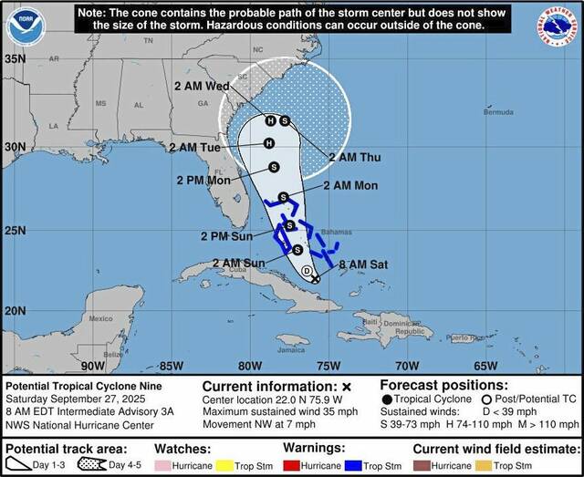
Imelda could form, stall and dump rain on Southeast
The National Hurricane Center’s official forecast track calls for the new system, now dubbed Tropical Depression Nine, to become a tropical storm by Saturday night, then briefly a hurricane by early next week off the Florida coast. The forecast calls for it to slow and weaken as it approaches the South Carolina coast on Monday and Tuesday, and could spend almost 24 hours in virtually the same location just offshore.
Slow-moving storms mean heavy rain becomes “a significant threat,” said hurricane center director Michael Brennan. “We don’t know exactly where that heaviest rainfall will occur but that would be in addition to some of the heavy rainfall we’re seeing across portions of the southeastern United States this weekend.”
“There’s an increasing threat of heavy rainfall early next week from coastal Georgia through the Carolinas and into the Mid-Atlantic states, which could cause flash, urban, and river flooding,” Brennan said. “So, everybody along the coast of South Carolina, North Carolina, from Georgia, all the way up into the southern mid-Atlantic states is going to want to pay attention to the forecast for this system as we go throughout the weekend.”
However, greater uncertainty than normal remains in the forecast.
As the storm approaches, a combination of factors is not giving meteorologists the comfort they’d like in making their forecasts. That includes the influence of an approaching cold front and upper level disturbance over the region, questions over the speed and timing of the system and Humberto, and the potential for an unusual interaction between the two tropical systems as they approach each other early in the week that could affect one or both of their trajectories.
Meanwhile, the unrelated rain event bringing heavy rain into the Appalachians and Southeast is setting up a potential for greater flooding even before the tropical weather moves in.
Hurricane Humberto and the Fujiwhara effect
At 11 a.m. Saturday, Humberto was a Category 4 hurricane with maximum sustained winds of 145 mph. Humberto rapidly intensified the previous day, its wind speeds increased 80 mph in 24 hours. Humberto was centered about 365 miles north-northeast of the Northern Leeward Islands, moving west-northwestward at 8 mph.
For days now, computer models used in forecasting have been hinting at the potential for a Fujiwhara effect between Humberto and the potential tropical storm, said Brian McNoldy, a senior research associate at the Rosenstiel School of Marine, Atmospheric and Earth Science at the University of Miami.
It’s a phenomenon that occurs when two cyclones near each other begin to spin around a common center point between them rather than moving independently. That interaction could cause one storm to absorb another, the two storms to merge, or both storms to move off in different directions.
That potential “makes the track and intensity forecast for each more challenging,” said Dan Brown, hurricane specialist branch chief at the hurricane center. As a result, the hurricane center and its partners have been scheduling frequent flights over the western Atlantic in the hurricane hunter aircraft to collect information about the storms and their surrounding environment, Brown said. The weather service also has been launching additional weather balloons to gather atmospheric information.
On Friday, one model showed a one-in-three chance of the Fujiwhara effect, McNoldy told USA TODAY. “It’s certainly within the realm of possibilities that Humberto and future-Imelda rotate around a common “centroid” in the Sunday-Tuesday timeframe,” he said.
As a rough rule of thumb, the separation distance between the storm centers needed for the mutual attraction to occur is around 800 miles, but that’s not a hard and fast number, he said. Their relative sizes and intensities also have an influence.
“Since Humberto will be so much larger and stronger, the centroid would be much closer to Humberto’s center, so that storm’s track would only feel a slight nudge, while future-Imelda could feel a significant tug and even get slingshot out to sea before reaching the coast.”
On the other side of the situation, each of the two storms could move on as if the other didn’t exist, he said.
Heavy rain ahead of tropical weather creates another layer of danger
The chance for serious flooding is thanks in part to a weather phenomenon that meteorologists call a “PRE” (Predecessor Rain Event).
“The setup this weekend could produce a Predecessor-like Rain Event or PRE well ahead of future Imelda,” said WPLG-TV hurricane specialist Michael Lowry on Sept. 26. “A PRE is a heavy rainfall event that can occur hundreds of miles north of a tropical system from a channel of rich tropical air flowing toward a frontal zone.”
These PREs are usually worsened by the presence of a nearby upper-level area of low pressure – like the one forecast this weekend over the Tennessee Valley – that help trigger the atmosphere to wring out the copious tropical moisture overhead, Lowry said.
An extreme version of this happened a year ago in the North Carolina and Tennessee mountains ahead of Hurricane Helene.
How much rain could fall in the Southeast?
Between 5 and 10 inches of rain could fall in the coastal southeastern parts of North and South Carolina through the first couple days of October, the Weather Prediction Center said. Higher totals could fall locally, and could lead to “scattered pockets of flash flooding,” the Weather Prediction Center said.
From far eastern Georgia to central Virginia, 2 to 4 inches could fall, while the Carolina coasts could see upward of 8 to 16 inches, according to AccuWeather meteorologists.
“Rainfall of this magnitude can lead to widespread life-threatening flooding, especially if the storm slows down or stalls,” AccuWeather said.