ORLANDO, Fla. — As if the 2020 hurricane season needed another reason to be remembered, meteorologists are now predicting two hurricanes may hit near the same location at about the same time.
The phenomenon is one that has never been recorded before, according to the National Oceanic and Atmospheric Administration.
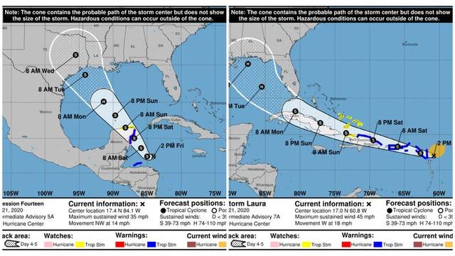
On Friday, the National Hurricane Center forecast Tropical Storm Laura and Tropical Depression 14 to both hit the Gulf Coast hours apart; Laura as a Category 1 hurricane and TD 14 as a tropical storm.
“The odds of something like that happening are very, very slim,” said WOFL-TV meteorologist Jayme King.
King also noted the phenomenon is so rare, that in 23 years of covering weather, he’s never seen it happen.
“When you think about the water basin size of the Gulf of Mexico, that alone is a novelty itself. It’s such a small confined area. I mean think about the Atlantic and other oceans. The Gulf looks like a pond compared to those, and now you have two circulating storms sandwiched into one basin? That’s quite a feat. The accumulation of all that cyclonic energy all in one place is very rare.”
It’s another strange milestone in the 2020 season, which was predicted to have between 19 and 25 named storms — the largest forecast ever made by the NHC. Also, the season was reported to have the earliest 10th named storm ever observed by the NHC — typically the 10th named storm of the year does not develop until around mid-October.
If TD 14 does develop, it will receive the name Marco and is forecast to become a Category 1 hurricane Sunday night. It should de-escalate into a tropical storm and make landfall on the Texas coastline early Tuesday.
Meanwhile, Laura is predicted to strike the Florida panhandle, Alabama, Mississippi and Louisiana coastlines by early Wednesday.
While the phenomenon is unique, other situations have come close to earning the record first, according to NOAA records.
The first close-call occurrence was on Sept. 4, 1993 when a major hurricane was over South Florida and another major hurricane was over the western Gulf of Mexico.
Laura and the possible Marco will not however be the first two storms to tango in the Gulf together. That honor belongs to Hurricane 8 and Hurricane 11, which overlapped by four hours on Sept. 5, 1933.
It happened again on June 18, 1959 with Tropical Storm Beulah and Hurricane 3, which overlapped with each other for eight hours.
The most recent occurrence was between Sept. 5 and Sept. 6, 2002, with Tropical Storm Fay and Tropical Depression Edouard when they took a dip together in warm Gulf waters for 18 hours.
NOAA also has 10 occurrences of two hurricanes making landfall in the United States within days of each other. One such event took place in 1933 when Hurricane 8 and Hurricane 11 made landfall one day apart in Texas and Florida.
Still, days lie in between the next week’s forecast and the time either storm could make landfall. Land mass between Tropical Storm Laura and the Gulf states’ coast lines could weaken or shift the storm’s trajectory, King said.
When King saw the NHC’s forecast he noted the novelty of the prediction, but was slightly disappointed the storms weren’t predicted to observe a different phenomenon — one of the strangest weather events known as the “fujiwhara effect,” which is when two nearby cyclonic storms begin orbiting each other in a meteorological ballet.
“You know our mission is to keep people safe first and foremost,” King said. “But deep down, as a weather guy, to see a feat like that is slim. It doesn’t happen often. It would be remarkable if it did. I’m just saying, I wouldn’t be disappointed.”
The only example of the phenomenon on record was in 2017 between hurricanes Hilary and Irwin.
Nothing has been ruled out for next week’s forecast which could see the development of two hurricanes. King noted that while the storms are two separate systems, they aren’t isolated to each other. If Tropical Depression 14 becomes strong enough it could have a detrimental effect on Tropical Storm Laura.
“If that happens, the circulating air on rotation would serve as a conveyor belt of wind shear to Laura’s western side,” King said. “It’s a very interesting scene in the Gulf. Get your popcorn.”