A pair of storms will keep things stirred up along the Atlantic Coast for much of the week. While a direct hit on the United States from either storm is not in the forecast, Bermuda may not be so lucky.
Tropical Storm Imelda, forecast to become a hurricane on the morning of Sept. 30, and Hurricane Humberto, still a Category 4 hurricane, will create large surf, coastal flooding and risky rip current conditions along the Atlantic Coast from Florida into the Northeast.
Both storms could affect Bermuda over the next few days, with Imelda the more significant threat.
Here’s what to know about both storms this week.
Imelda to stay offshore
There’s increasing confidence that Imelda will stay well offshore of the southeastern United States coast, Eric Blake, a senior hurricane specialist at the National Hurricane Center, wrote in a morning update on Monday.
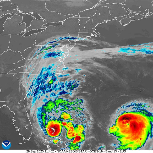
Imelda is moving northward at about 8 mph, being steered along the western side of a high-pressure ridge over the Atlantic, Blake wrote. But to its northeast, Hurricane Humberto, still a Category 4 hurricane with 140 mph wind, is forecast to erode the ridge by Tuesday, Sept. 30. That will cause Imelda to abruptly turn to the east-northeast and speed up.
Despite Imelda steering away from the Eastern U.S., impacts will still be felt across parts of the Southeast, including coastal South Carolina. Meteorologist @JimCantore is in Folly Beach where scattered showers and high surf are possible. pic.twitter.com/9I49t0sxxG
— The Weather Channel (@weatherchannel) September 29, 2025
Imelda is forecast to become a hurricane within 24 hours, and the center’s forecast track indicates it could strike Bermuda on Thursday as it moves northeastward. A hurricane watch was hoisted for the island of Bermuda on Monday afternoon.
It would be the fourth hurricane of the 2025 hurricane season. A typical season sees roughly seven hurricanes, according to Colorado State University.
What U.S. impacts are expected from Imelda and Humberto?
Both storms are forecast to create rough conditions along beaches and for small vessels offshore.
“Swells and high surf from both Humberto and Imelda are expected to produce dangerous marine conditions and rip currents along the east coast of Florida and the Georgia coast today,” the hurricane center said. “These conditions are expected to spread northward along much of the east coast of the United States early this week.”
The National Weather Service urged caution on Sept. 29 for inexperienced boaters and swimmers at locations along the coast.
As for rainfall, a wide swath of 1-2 inches could fall from far eastern Florida to coastal North Carolina, AccuWeather said. “There can be 2-4 inches of rain from far eastern South Carolina through southeastern portions of North Carolina. Lighter rainfall will extend inland across the Carolinas and southeastern Georgia,” according to an email from AccuWeather.
Unbelievable satellite imagery of the dual tropical cyclones off the East Coast of the US, Major Hurricane Humberto and Imelda.
— Colin McCarthy (@US_Stormwatch) September 29, 2025
Imelda’s cloud shield stretches over 1,400 miles, covering nearly the entire East Coast. pic.twitter.com/kKqC8jopH3
Impacts by state
North Carolina: Along the North Carolina coast, the weather service has issued a coastal flood warning for potential moderate oceanside flooding into Tuesday, Sept. 30. The warning includes Hatteras and Ocracoke islands and eastern Carteret County.
“The greatest potential for impacts will be along the vulnerable portions of Highway 12 on Ocracoke and Hatteras Islands,” wrote meteorologist Casey Dail in a Sept. 29 forecast from the weather service office in Morehead City, North Carolina.
“Portions of Hwy 12 may be impassable at times due to the ocean washing over dunes, especially around times of high tide,” Dail said. Earlier in September, the flooding caused another home to collapse in Buxton on the Outer Banks, in an eroded area where six homes collapsed in 2024.
Coastal flood advisories have been issued along the remainder of the Outer Banks, and for portions of Pamlico, Craven, Carteret and Onslow counties. Minor coastal flooding also is possible along the sounds, the weather service said.
Florida and Georgia: Sustained wind of 20 to 30 mph, with gusts up to 40 mph, are forecast in the coastal counties of Central Florida through early morning on Sept. 30, said the weather service office in Melbourne, Florida. At the beach in the Central Florida coast, the weather service reports rough 6 to 10 foot surf is expected on Sept. 29.
In Northeast Florida and Southeast Georgia, dangerous beach and boating conditions, including rip currents, high surf, breezy winds, minor beach erosion and minor tidal flooding, are forecast through the week, the weather service said.
Hurricane watch posted in Bermuda
Imelda is forecast to approach Bermuda by the middle of the week, forecasters warned. A hurricane watch is now in effect for the island of Bermuda due to the expected onset of tropical storm conditions beginning Wednesday Oct. 1 afternoon, the hurricane center said.
“Exactly where it passes Bermuda, a tiny speck in a large blue sea, remains to be seen,” said Houston-based meteorologist Matt Lanza in a Substack post.