


OKLAHOMA CITY — Parts of the Southern Plains counted the injured and surveyed the damage Monday after tornadoes and other powerful winds swept through, killing at least one person in Oklahoma, while some Michigan residents faced a fifth consecutive day without power following last week’s ice storm.
In California, the National Weather Service said winter storms will continue moving into the state through Wednesday after residents got a brief break from severe weather Sunday.
Parts of the Northeast that have seen little snow this winter were under a winter storm warning. And forecasters warned of continued high winds in parts of the Plains and of thunderstorms and possible tornadoes in the Ohio Valley.
Another active day of severe weather today. This time across the Ohio River Valley. Damaging winds & few tornadoes possible. We're live on @wunderground from 1-5PM ET! @mikebettes @TWCAlexWilson @DrRickKnabb pic.twitter.com/PoiZaXeD8r
— Weather Underground (@wunderground) February 27, 2023
A look at the weather threats around the country:
Tornado forecast, cleanup
Thunderstorms were forecast Monday to produce damaging gusts across the Ohio Valley, according to the Storm Prediction Center. The weather service forecast strong winds Monday in Kansas and Missouri, with gusts topping 60 mph.
The storm system produced at least four tornadoes as it moved across central and northeastern Illinois on Monday, including two that formed in suburbs west of Chicago, authorities said. Initial reports suggested damage there was limited to fallen trees or shingles torn from buildings, said Rafal Ogorek, a meteorologist in the Chicago office of the National Weather Service.
At least eight tornadoes touched down in Oklahoma, several feet of snow fell in parts of California and a dust bowl swept through Northern Texas over the weekend, as powerful and dangerous weather affected communities across the U.S. https://t.co/bsSG0QCSwe pic.twitter.com/EOj48kDYaT
— CBS Mornings (@CBSMornings) February 27, 2023
At least one person was killed and three others injured after a tornado touched down Sunday night in far western Oklahoma near the town of Cheyenne, where 20 homes were damaged and four others destroyed, Roger Mills County Emergency Manager Levi Blackketter reported.
Officials in Norman, Okla., confirmed 12 weather-related injuries after tornadoes and wind gusts as high as 90 mph were reported in the state Sunday night. The winds toppled trees and power lines, closed roads and damaged homes and businesses around Norman and Shawnee.
Classes were canceled Monday at two damaged elementary schools, said Norman Police Chief Kevin Foster.
.@NOAA's #GOESEast????️ tracked the #severe #thunderstorms that raced across Texas, Oklahoma, and Kansas yesterday evening.
— NOAA Satellites (@NOAASatellites) February 27, 2023
The destructive storms produced frequent #lightning, large #hail, damaging winds, and nine reported #tornadoes.
More: https://t.co/ICRw4nnEVQ pic.twitter.com/Gr3DhHIh5i
Frances Tabler, of Norman, told KOCO-TV that she suffered a small cut on her head when a storm hit her home, tearing off much of its roof and sending debris flying. She said it was a miracle her children weren’t hurt, although her daughter was trapped for awhile in a bedroom.
“It was just like a blizzard in the house with all the debris flying,” Tabler told KOCO. “I was screaming for my kids.”
Damage from the Norman, OK tornado is extensive. NWS Norman is surveying multiple areas and can already confirm EF-2 damage in multiple spots. The full report on storm strength, width and length to follow. pic.twitter.com/khPuXNtot2
— WeatherNation (@WeatherNation) February 27, 2023
The line of quick-moving thunderstorms that produced a swath of damaging wind gusts across likely qualified as a derecho, although that’s not an official designation, said Nolan Meister, a National Weather Service meteorologist.
Meister said a wind gust of 114 mph was recorded in Texas, with gusts between 70 and 90 mph in central Oklahoma.
More than 76,000 customers lost power in Oklahoma, but most had it restored by Monday morning, Oklahoma’s Office of Emergency Management reported.
There were reports of nine tornadoes in Kansas, Oklahoma and northwestern Texas, weather officials said. One tornado near Liberal, Kansas, damaged more than a dozen homes and caused minor injuries to one person, KSNW-TV reported.
Blizzard conditions in Western U.S.
Blizzard warnings went into effect Monday in the Sierra Nevada range as more rounds of rain and snow moved into California and Nevada.
A blizzard warning was in effect for most of the Sierra Nevada into Wednesday and an avalanche warning was issued for the backcountry around Lake Tahoe, where up to 6 feet of snow was expected over the next two days in the upper elevations and gale-force winds could create waves up to 5 feet high on the lake, the National Weather Service in Reno said.
State offices across northern Nevada and the Nevada Legislature in Carson City both shut down on Monday due to the winter storms.
We're LIVE with the latest on two winter storms! #Piper #Quest @JMichaelsNews gives an update from Lake Arrowhead, California: pic.twitter.com/vLka3rH3eK
— The Weather Channel (@weatherchannel) February 27, 2023
The new series of storms arrived even as parts of California were still digging out from last week’s powerful storm, which added to a massive snowpack left by a siege of “atmospheric rivers” in December and January.
In the Sierra, Yosemite National Park announced it would be closed until midweek, and numerous roads were closed in Sequoia National Park. Trans-Sierra highways were subject to closures and chain requirements.
East of Los Angeles, all roads to San Bernardino Mountain resort communities around Big Bear Lake remained closed because of last week’s huge snowfall. One route to the Mojave Desert was open only to downhill traffic. In the San Gabriel Mountains, roads remained closed to the Mountain High resort, where the storm dumped 7 3/4 feet of snow.
A significant storm over the last several days created many impacts across California, causing some cities to flood, and higher elevations to record several feet of snow. #CAwx
— AccuWeather (@accuweather) February 26, 2023
Full recap with photo gallery: https://t.co/TB5oshfeuj pic.twitter.com/U8a7KvBqtM
The northbound side of Interstate 5, the West Coast’s major north-south highway, was shut down by wintry conditions and disabled vehicles about 90 miles south of the Oregon line. Interstate 80, the major route between San Francisco and Lake Tahoe and Reno was closed due to whiteout conditions.
Suburban Santa Clarita, in hills north of Los Angeles, received its first significant snowfall since 1989.
“We went outside and we let our sons play in the snow,” Cesar Torres told the Santa Clarita Signal. “We figured, while the snow’s there, might as well make a snowman out of it.”
Storms in Michigan, Northeast
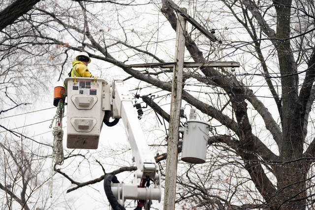
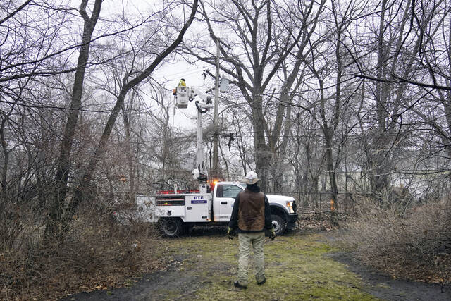
In Michigan, still reeling from last week’s ice storm and high winds, more than 180,000 customers were without power Monday, according to PowerOutage.us. That was down from more than 800,000 at one point last week. Crews continued their work to restore all electricity.
Leah Thomas, whose home north of Detroit lost power Wednesday night, finally got her power back Sunday afternoon — only to have it go out again at midday Monday.
“It’s very frustrating, very frustrating,” she said. “I’m just going to hope and cross my fingers that it comes back on here soon.”
Heaviest of snow today will be Northern #Wisconsin and Northern #Michigan. #GreenBay current snow depth = 9" #TraverseCity current snow depth = 8". #wiwx #miwx pic.twitter.com/yB4GuLMmpJ
— Mike Bettes (@mikebettes) February 27, 2023
In Michigan’s rural Livingston County, Jo Ann Davis, 59, said Monday she really wanted a shower since she and her husband, Tim, 61, have been without power since last Wednesday night.
They have no electricity for lights or appliances, of course, but their biggest problem is no water. They rely on a well that uses an electric pump.
“We’re actually scooping water from a creek with 5-gallon buckets and then dumping it in the toilets to flush,” Davis said. “I haven’t showered since last Tuesday.”
While not expecting a blockbuster storm by regional standards, southern New England braced for what could be the most significant snowfall of what has so far been a mild winter.
A winter storm warning covered parts of the Northeast, including Connecticut, New York, Massachusetts, New Jersey and Rhode Island, with heavy snow forecast for Monday evening through Tuesday afternoon.
Boston could get 5 inches and a messy Tuesday morning commute, according to the weather service. As much as 10 inches could fall in western Massachusetts, northwest Connecticut and southern Vermont.